COR™ certified

Monteith & Sutherland Ltd. is now COR™ certified

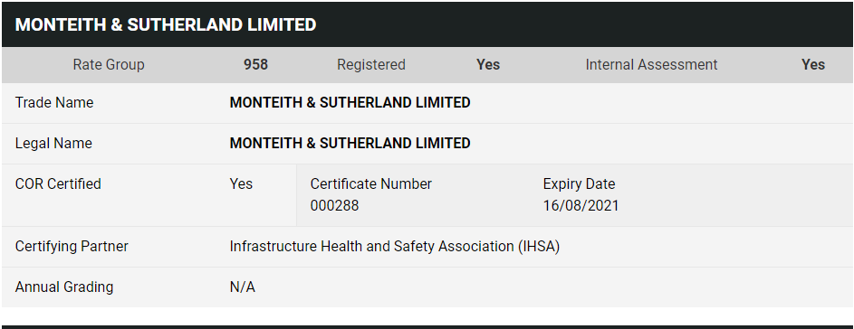
We are excited to announce Monteith & Sutherland Ltd. is now COR™ certified!

This great achievement was possible thanks to the relentless implementation of the rigorous, solid Health & Safety procedures on all the levels, a thorough gaps-analysis, internal and external audits and, of course, an amazing team-work.

Presently, as of August 16th, 2018, Monteith & Sutherland is the first and only COR™ certified surveying company in Ontario.

COR™ certified
MS COR™ certified
Dixie-QEW, Microtunnelling, Surveying

Featured Project: Microtunnel alignment surveys, Dixie-QEW Storm Sewer

Monteith & Sutherland crews work with CRS Tunnelling Canada project team to ensure the microtunnelling of the 1200mm storm sewer at Dixie-QEW is going per design alignment.

Precise traversing, while crawling, bending and crouching, and carrying the survey equipment all the way to the heading in and back to the portal is a very demanding task. Our crews do an outstanding job, delivering excellent surveys data sets, and performing all tasks in a safe manner.

Hamilton Barton St Overflow HDL Pointcloud Snapshot

Featured Project: Pre-rehabilitation HDLS survey of overflow sewer

Last month Monteith & Sutherland have teamed-up with PipeFlo and performed pre-rehabilitation high definition laser scanning (HDLS) survey of overflow sewer at Barton Street between Weir St North and Fairfield.

The survey was completed with P40 Leica HDL scanner. The data were processed in Leica Cyclone, and cross-sections at 1 metre interval, along with best fit centreline of the structure, were generated in 3D Reshaper:

Hamilton Barton Overflow HDLS Cross-sections

Thanks PipeFlo for the highest safety practices pertaining the confined space entry, and for all the help during the survey.


Featured Project: TTC Subway Survey

Monteith and Sutherland crews worked on a comprehensive survey for the TTC‘s Bloor-Yonge and Pape stations.

Soheil Namdari, pictured above, lead one of the Survey crews completing the control and topographic surveys at Pape Station. The survey crews performed precise traversing and levelling from local City of Toronto control monuments to Pape station. A street-level topopgraphic survey around Pape Station was completed for future planning purposes. We also searched for boundary evidence and completed a cadastral survey to confirm the Pape Station property limits.

At Bloor-Yonge Station project, the crews traversed and levelled from local City of Toronto control monuments to platform level, and then into the tunnels. The control network was then adjusted and used to coordinate the High-Definition Laser Scanning campaign. The challenge of the project has been the time constraints and limited work windows to ensure regular TTC services are not impacted. The use of a HD-scanner was imperative to get big volumes of detailed data as quickly as possible. Our Leica P40 Leica scanner is very quick and of the high precision.


Featured Project: Peel Region Sewer Tunnel Verification

Our crews have been busy assisting Technicore Underground Inc. with verifying the tunnel alignment and ensuring the correctness of the traverse. The survey crews have performed precise traversing from the surface into the tunnel heading.

The long distance to get underground is challenging, and along with varying ambient conditions in the tunnel can cause significant error in the traverse. To mitigate that, and to ensure the highest accuracy of the traverse, our crews used a gyroscopic theodolite, which is one of the few available in Canada. We use a DMT GYROMAT3000, that is the most accurate north-seeking precision-surveying gyroscope in the world. The GYROMAT helps us obtain most accurate azimuths, and thus mitigate accumulative errors in the underground control networks, notably in the long-driven tunnels.

The tunnel being mined is part of the Region of Peel’s East Trunk Sewer twinning to improve wastewater service and allow for growth on the system. The Region of Peel has commissioned the installation of a large sanitary sewer pipe along Erin Mills Parkway, Lincoln Green Way and Lincoln Green Close.


Featured Project: Cherry Street Lakefill Hydrographic Survey

Glenn Dawson, and his crew braved the cold and icy weather to collect bathymetric data around the Essroc Quay. The crew equipped a nineteen-foot Boston Whaler boat with a single beam echosounder.

The sounder obtains depth data at a predetermined frequency as the boat moves around the harbour along a pre-planned runlines. A GNSS unit collects positional data of the transducer in real time.

This task was completed as part of Cherry Street Stormwater and Lakefilling project which is the first step to improve the area for reuse and naturalization.


Featured Project: HWY 600 Vertical Control

On a recent project in Rainy River, 1,800km northwest of Toronto, Monteith & Sutherland established precise elevations along Highway 600 using digital levels and invar rods, and by implementing first order levelling procedures. Check out the video below!

M&S guest lectures at UNB

Monteith & Sutherland had a fantastic weekend presenting at the University of New Brunswick for the department of Geodesy and Geomatics Engineering. It was a privilege to collaborate with Dr. Robert Kingdon and provide students with a laboratory assignment using our DMT Gyromat 3000, a precision gyroscope used to correct underground traverse orientation.

And not to mention, Dr. Kingdon, along with the outstanding faculty, and our own company president Glenn Dawson (a graduate from the class of ’88), demonstrated why UNB is a world leader in geomatics academia.

For more information on the Geodesy and Geomatics Engineering program at UNB, click here.